penewobikong - thessalon to Blind river
club contact:
Manager- Carolynn Reid – Phone: 905-317-1765
Trail Captain – Andy Penikett penikja@personainternet.com
Penewobikong Hiking Group – Melanie Hall melanie.hall369@gmail.com
Feel free to contact us regarding trip planning and possible shuttling, depending on volunteer availability.
Join our Penewobikong Facebook Group for trail updates and planned hikes.
maps for penewobikong trails
Thessalon - iron bridge - Blind river
Interactive Web Map (overview of all trail maps for Clubs of the VTA): CLICK HERE
This map shows the full extent of the completed sections of Voyageur Trail.
It is not intended for hiking purposes. The zoom level is restricted
and it does not contain any descriptive information.
From this page you can also view our whole suite of mapping products.
Members of the VTA have full access to these products,
plus they receive an Access Code for our digital maps on the Ondago App.
To purchase your membership, CLICK HERE
Immediately upon receipt of payment members get access (downloadable instructions) to the latest map products covering close to 500 km of trail.
Only the official maps and route descriptions from the Voyageur Trail Association on the Ondago app are accurate, reliable and trustworthy.
Club Updates and other important information:
No updates available at this time.
Trail Sections We Manage:
Desbarats-Huron Shores Section (9 segments)
- The Desbarats-Huron Shores trail section comprises 77 km of main linear trail and 15 km of side trails between Tower Lake and the village of Iron Bridge. The linear trail is broken down into nine segments that can be hiked (in whole or in part) either as out-and-back outings or as through-hikes by walking back along roads or parking a vehicle or bicycle at the other end.
- The Desbarats-Huron Shores trail passes through an intriguing forested landscape that includes many scenic vistas, lakes, creeks and rivers between Tower Lake and the village of Iron Bridge. Highlights include Ottertail Lake, Shaw Dam Lake, Tea Lake, Basswood Lake, and the Mississigi River valley. A 15 km side trail leads into Bruce Mines, and the trail passes north of Desbarats and Thessalon. Trail users are taken through the Kirkwood Forest which was planted as a land reclamation project beginning in the late 1920’s. Numerous historic roads through the area allow access for forestry activities, and portions of the trail follow these roads.
- Desbarats-Huron Shores trails are classified as moderate or difficult. These trails are maintained by the Saulteaux and Penewobikong Voyageur Trail Clubs, supported by their members and volunteers-at-large.
- BEFORE YOU SET OUT:
All outdoor activities involve some degree of risk. Please, remember that your safety is your personal responsibility. So, be well prepared for your chosen activity and route. Let someone know where you are going and when you plan on being back. Make sure to bring adequate food and water with you for your hike. If you plan to venture off the trail system, make sure you have a compass and a map of the area. - Wear proper footwear, dress for the weather and bring enough water and food for the planned hike.
Penewobikong Section (5 segments + 1 loop trail)
- The Penewobikong Section comprises 45 km of main linear trail between Iron Bridge and Intersect Lake (north of Blind River), plus several side/access trails and one short loop trail. The linear trail is broken down into five segments that can be hiked (in whole or in part) either as out-and-back outings or as through-hikes by walking back along roads or parking a vehicle or bicycle at the other end.
- Penewobikong trails are classified as moderate or difficult. These trails are maintained by the Saulteaux and Penewobikong Voyageur Trail Clubs, supported by their members.
- BEFORE YOU SET OUT:
All outdoor activities involve some degree of risk. Please, remember that your safety is your personal responsibility. So, be well prepared for your chosen activity and route. Let someone know where you are going and when you plan on being back. Make sure to bring adequate food and water with you for your hike. If you plan to venture off the trail system, make sure you have a compass and a map of the area. - Wear proper footwear, dress for the weather and bring enough water and food for the planned hike.
club info:
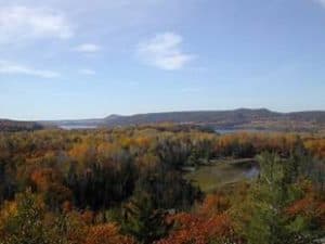
The Penewobikong section of the Voyageur Trail is a wilderness recreational hiking trail about 45 km long. It passes numerous picturesque lakes and rivers and climbs several rocky promontories. The diversity of the landscape and abundant access points make it very appealing and well worth exploring.
Construction on the Penewobikong section began in 1973. Norm Lediett laid out the trail and constructed it with the help of four club members. Norm finished the trail in 1988.
Nearly half of this trail section runs through the Mississauga First Nation or individuals. It is only with their ongoing permission that we can maintain this trail. The VTA expresses its sincere gratitude to these landowners.
A historical note: During World War II, part of this section was logged out. The yellow birch taken from the area went south to make the strong, pliable birch veneer used in the construction of the famed Mosquito Bombers.
Local Information:
Links of Interest:
Related Materials:
Trail Sponsors
